Friday, December 3, 2021

Arizona to California

Arizona continued to overdeliver on Historic 66. If we hadn’t wanted to stop or have a look at anything, Jane the navigation app was happy to have us continue for 85 miles without a turn!


Burma-Shave signs west of Seligman


But of course, we did stop. First in Peach Springs, headquarters of the Hualapai Reservation, whose fish and game ministry is housed in a hundred-year-old cobblestone building. I went in the general store next door which, I was happy to discover on purchasing them, had doughnuts light and fluffy enough to rival any on Route 66.


I also saw only our second rainbow sticker in 24 hours, and of the entire trip (the first was in a shop window in Flagstaff). T. commented on how busy the railroad was. She also wondered what will happen to all the gasoline-powered cars when someday electric cars become compulsory. I think she’s underestimating Americans’ capacity to resist compulsion, but I could be wrong.


Truxton


Big tumbleweeds rolled across the road. Towns were so small it was easy to roll right past them too, but I wanted to stop at Hackberry. The general store there is full of vintage Route 66 stuff, and was the base for the late Bob Waldmire, artist of the Route (whose stuff we’d been seeing since Pontiac, Illinois).


Hackberry General Store


Antares

Before we knew it we caught our first sight of the interstate in days. This was the turn Jane had been telling us about, into downtown Kingman.


I remembered seeing signs for Historic Route 66 on previous drives through Kingman, which is why I’d mistakenly thought it had been replaced by I-40. Kingman is a railroad town and I’d known it only as an important place to stop and get gasoline. I’d never noticed historic downtown before.


Restored Hotel Brunswick (1870s)

The Powerhouse contains a visitor center and museum, but it was closed for Veterans Day. The building used to house the Desert Power & Light Company, which provided the power to build Hoover (Boulder) Dam.


We decided to stop for lunch instead. I’d learned by now that diners are really hit and miss with the pink lemonade and Mr. D'z was a miss—tasted like cleanser—but the food was good.


I-40 does follow the post-1952 alignment of Route 66 west of Kingman. But we turned out of downtown on the earlier alignment, to take us across the Sacramento Wash to the historic Back Country Byway. 


That morning, still parked at the Historic Route 66 Motel in Seligman, I’d ventured to show something to T. “I know you’re not used to automatic cars,” I said, “but let me show you how to manually change gears in this one.” I then showed her the “paddles” on the steering wheel for shifting up or down, which even I recognize is not an interesting or satisfying way to shift gears. But today’s stretch of old Route 66 was one of the most interesting—the Oatman Highway—and, while I knew T. would want to drive it, it has some pretty steep grades.


Prior to 1952, this was Route 66 across the Black Mountains. Hard to believe today, with warnings signs about not taking an RV and watching out for bighorn sheep and burros in the road. We first stopped at Cool Springs, a 1926 stone store and camp that was abandoned after the 1950s realignment. After being destroyed as a set in a Jean-Claude Van Damme action movie, it was lovingly restored in the twenty-first century.


Then we started up the hairy switchbacks. There was a viewing spot where we pulled over carefully and walked up. 


The burros are here because their ancestors were brought by miners to Oatman when it was a mining camp. They continue to roam freely today, although I wouldn’t join in the feeding of them as they might bite.

We pressed on towards the highest point, Sitgreaves Pass.


After the summit, the curves led down to Oatman.


The name comes from Olive Oatman, a young girl who was captured and possibly sold (the legend, and the tribe, depend on who’s telling the story). She certainly ended up with a tattoo on her chin, like Mojave women, and was ultimately bought back in a trade with fort authorities. Oatman was never a town and today it’s a literal tourist trap, as you can get stuck on the main street between burros and gunfights for show. There was plenty here to entertain while we walked around and rested T’s braking foot.


Following the 1952 realignment, people didn’t have to drive the tight curves of the Oatman Highway anymore, and hardly anyone was left here until the revival of Historic Route 66. But from 1908 to 1915, Oatman was a gold rush town, with twenty saloons and mining operations worth $25 million (meanwhile, only 300 people lived in Kingman). World War II demanded metals other than gold so the U.S. government shifted mining priorities from 1941. Some people are still mad about that. 


All along Route 66 are these ghosts of people and ways of life that were once very vibrant. In other cases, Route 66 is a reminder of people and ways of life that continue going along just fine, despite being invisible or ignored from the outside mass-media world.


Eventually, the Oatman-Topock Highway took us to water! We stopped for a glimpse of the Colorado River before crossing it into the final state of our journey.


Just before we got to California, we saw a blur of speed cross the road. “That’s a roadrunner,” I said, imitating the cartoon sound. T. had never seen one. Of course it was too fast to get a picture of, so here's a motel sign from Tucumcari, NM instead.


At the state line, everyone has to join the interstate go through California’s agriculture inspection, not that anyone looked in our car. We then turned off once again onto the U.S. highway, which became Broadway into Needles.


Needles's former Masonic temple is now a theatre and was welcoming the class of 1961 to its reunion.


Needles also has a former Harvey House (the El Garces, built by Frances Wilson and now closed) and probably other features, but we were preoccupied with finding a motel. Ideally I wanted to do laundry, as we had plenty of time, but everywhere we went either didn’t have laundry facilities or said they didn’t (advertised that they did, but the machines were locked up or all said “out of order” on them). I think this was to do with California’s longstanding drought but it might have been blamed on COVID/social distancing; who knows? No explanations were offered. One motel we left because the guy tried to get T. to give him her PIN, since he also couldn’t bring the card reader over to the plate glass window (despite which he also refused to lower his mask). And, of course, gas had doubled in price. We were already finding California hard work.

Charles Schulz once lived and created the character of Spike in Needles.


Finally, we agreed not to do laundry and go back to the Motel 6, which had welcomed us in a friendly manner and was a short walk from a Chinese restaurant.


We passed a peaceful night, other than the people next door getting up at 5:30 A.M.—to party, not to leave. There was a pot dispensary next door so maybe that had something to do with it. When we checked out, the proprietor apologized to me; he and his wife were personally cleaning the rooms. I had not, in fact, slept badly--being a tour director is exhausting! Where to stay, when to do laundry, which alignment to take, which places of interest to stop. Mostly fun, of course, and it had all gone remarkably well.


Just past the Chinese place was the Wagon Wheel restaurant, with menus illustrated by Bob Waldmire. We stopped for breakfast. There was a poster advertising your friendly neighborhood “coffee with a cop.” T. said “the cops won’t be impressed with this coffee!”

Billboards advertised an “Indian & Mexican Restaurant” and, in a sign of the valley agriculture that used Needles as an icing station, “Fresh Pistachios.” Forgetting to stop for gas, we began our crossing of the Mojave Desert.


Pre-1931 Route 66 took us to the ghost town of Goffs. Needles residents used to go to this elevation to escape the heat, until the Route was realigned.

Ghost town


It’s not, thank goodness, that we were close to running out of gas. It’s that what looked expensive in Needles looked positively cheap by Fenner! But we had to stop there, as there is nowhere else for 55 miles. In the nineteenth century and railroad days, Fenner was a popular watering stop, which is more or less how the Hi Desert Oasis still functions today.


Pre-1931 Route 66 is to be preferred here, as it avoids I-40 (which also climbs a steep grade through the South Pass of the Sacramento Mountains). Unfortunately, we could not take the pre-'31 Route to Cadiz Summit, so we had to take the Kelbaker Road detour described in Jerry McClanahan’s EZ66 Guide. I mention this detail because McClanahan estimated the road (closed due to washouts) would reopen in 2016-17, but instead, it’s remained closed for six years and counting. We could have backtracked to Cadiz from the west—it was signed only “no through road”—but instead, we pressed on to Amboy. Amboy is the first of a number of towns that were named alphabetically from west to east (Cadiz, Fenner, Goffs). There is not much left of any of them today—the school at Amboy appeared to be closed, though there is a post office. From miles away, one can see the Amboy Crater. It’s only six thousand years old, but at least it was free to view.

Amboy Crater with train in foreground


The star of Amboy is Roy’s Motel & CafĂ©, from 1938 the only travelers’ stop for miles. A businessman bought the whole town and today, while the motel is no longer operating, you can go in and buy gas, etc. As would become a trend in California, the plumbing wasn’t up for visitors and we had to use portable toilets.


The water problem, the failure to repair roads (California has, I understand, been broke for a while now), the obvious fact that, while the climate crisis still seems abstract to some people in other places, it’s already arrived here. All of it added up to a very poor impression of Route 66’s eighth and final state. Is this the future, born of those golden years of mining and burning through fossil fuels like there was no tomorrow? (The irony of being on a nostalgic road trip is not lost on me.)

The iconic Roy’s sign is in the mid-century Googie style, a futuristic design inspired by the Space Age. But in The Grapes of Wrath, written earlier, John Steinbeck described the Dust Bowl travelers’ disappointment when they finally reached the promised land of California. Was this it? 


Route 66 in Amboy actually goes through the Mojave Trails National Monument. As we learned in the last U.S. administration, national monuments can come and go at the stroke of a president’s pen. Not so national parks, and the side trip on our itinerary here was to Joshua Tree, which we reached by turning south on the desert Amboy Road and driving 42 miles to Twentynine Palms.


Joshua Tree National Park was the first crowded place we’d been on our entire trip, Chicago included. It was outdoors, at least, and I guess November must be high season, since in summer the desert gets too hot. Los Angeles residents can reach the park’s southern entrance via I-10 to Palm Springs, but most of them appeared to be where we were, at the western entrance in the town of Joshua Tree. There was a line for the portable toilets at the visitors’ center—no water again—and a long wait to actually enter the park, which was also priced 50% higher than the other national parks.


Once we finally got in, it was a perfect day for exploring. The weather was a nice temperature, ranging down to the 60s Fahrenheit depending on elevation.


We took the popular Hidden Valley hiking trail. Hidden Valley was formed when someone blasted through the rocks to reveal a kind of meadow micro-habitat. It’s also popular with rock climbers, some of whom, including a young boy, we saw roped up high on the boulders.


From Keys View (5,000 feet) you can see as far as Palm Springs. Everyone else was there, too.


We didn’t hike far, but at least I’d gotten my boots dusty on a proper trail. After the obligatory photo op at Skull Rock, 


we made our way down to the cholla cactus garden.


In one of the parking lots we saw a wedding party emerge. The bride smiled for photographs, heedless of the dust, and we waved congratulations. “I have seen everything now,” T. said.


The changing light on the landscape of Joshua Tree was truly special. By sunset we were at the High Desert Motel, waiting for nightfall. From there I could not see as many stars as we had in Seligman, Arizona. But at least this place let me use the washing machine!


At least you can see the moon...


Friday, November 26, 2021

Route 66 in Arizona

 Our last few miles of Route 66 in New Mexico were scenic, winding up the sheer side of Devil’s Cliff. The state line at Lupton, Arizona has long been home to colorful trading posts.

On our detour north we’d seen billboards for McDonald’s 80 miles apart. We therefore knew that McDonald’s was the modern scale for judging the size of a town. But for much of this day we saw tacky billboards from the old Route 66 days, as we followed the Little Colorado River—and, inevitably, I-40.

 One section of the 1926-31 highway remains that was worth doing: a dirt county road over the Querino Canyon Bridge. 


The Petrified Forest is the one national park that Route 66 actually crossed. Today it’s crossed by the interstate, too, though there’s no access at that point. We exited I-40 north of the park and entered via the Painted Desert, an area of badlands. 


Perhaps because it was a cloudy day, T. was less impressed by the Painted Desert than I remembered being in 1987. She compared it to a slag heap. The sun does help to bring out the colors. Fortunately, in the parking lot, we happened to be in time for the U.S. Capitol Christmas Tree, which was making lots of stops in its big truck en route to Washington, D.C.


The Painted Desert Inn is now a museum and, like many other attractions along our route, was closed that day. Most of my interest was in the outside of the building though. It dates from 1924 and was built in Pueblo Revival style, and before it closed in 1942, it was managed by Fred Harvey’s company as a hotel for passengers on the Santa Fe Railroad, which we’d been following for some days.


The Painted Desert Inn was also our first look at the work of Mary Jane Colter, an important architect of the Southwest who, among other things, put in the glass to connect the building with the landscape. There are other interesting details such as the use of petrified wood.


A line of telephone poles indicates where Route 66 once passed right through, delivering travelers their first sight of the national park. The old alignment is marked by a 1932 Studebaker.


Having been through the “quarry” that T. called the Painted Desert, we entered the Petrified Forest. The view of “Newspaper Rock” showed us more impressive relics of an ancient civilization.


Annie Alexander, pioneer paleontologist, 1921


I was relieved to see the sun come out for our walk on the Blue Mesa Trail. It’s only a mile loop and paved with asphalt, but descends dramatically in among the petrified wood.


"Elephant skin" surface


Mesa with train


At the park exit stands one of the oldest national park buildings. We got a taste of what’s to come when we learned the plumbing wasn’t up to visitors. Lots of port-o-pots in our future.


We were now south of the park, and rather than backtrack 28 miles merely to get back on the interstate, elected to turn on U.S. 180 and rejoin Route 66 at Holbrook.


Joe and Aggie's, also closed

West of Holbrook, the Geronimo Trading Post advertised the “World’s Largest Petrified Tree.” It’s in pieces and T. was less than impressed. A more interesting use of petrified wood was in the welcome sign to Joseph City, named after Joseph Smith, the founder of the Church of Jesus Christ of Latter-day Saints.


Our destination for the night was Winslow, of which people of many nationalities have sung along to the Eagles’ “Take It Easy.” However, there were still a number of old signs to follow, culminating in a rough section of frontage road with grass growing on it. This led to the Jackrabbit Trading Post.


In its heyday, Route 66 had more than a thousand miles of signs telling people how far it was to the Jackrabbit—starting at Springfield, Missouri! Heaven knows how the owner afforded it, but the Jackrabbit Trading Post became a must-visit destination by the time people finally arrived, and it’s still there, and it was open.

Note little jackrabbits all along the top!


And so to Winslow, where we first stopped at the town’s September 11 Remembrance Garden. There are girders from the World Trade Center and a flag that was flown at the Pentagon. 


T’s highlight, though, which she’d been talking about for days, was Standin’ on the Corner in Winslow, Arizona, a statue of Glenn Frey by Ron Adamson. And a mural, and a park, and the biggest Route 66 shield ever painted on the intersection.


Frey and Jackson Browne wrote the song following Browne’s trip on Route 66:

"Well, I'm a-standin' on a corner in Winslow, Arizona.

Such a fine sight to see. 

It's a girl, my lord, in a flatbed Ford, 

slowin' down to take a look at me."


It was all buildup to our resting place for the night: La Posada. The last of the Fred Harvey hotels that once welcomed train passengers from Cleveland to California, and the masterpiece of Mary Jane Colter.


Unlike other Harvey Houses which are either closed or demolished, La Posada (1928) is beautifully restored. You can still board Amtrak trains behind the hotel. We stayed in the “Douglas Fairbanks” room, and it had a library!


The Harvey Houses have a special place in history because of the Harvey Girls, as the young hostesses who worked in the hotels were called (also a Judy Garland film). Young women, many of them immigrants, traveled across the country to work as waitresses, an unusually independent thing to do at the time. Harvey Houses also had the distinction of never being segregated, so La Posada is one of the few places in Arizona still open today that welcomed black travelers in the era of the Green Book.

I was kind of reluctant to leave the next morning. Everything about the hotel and grounds was beautiful.

Pollinator garden


Sunset, train stop behind La Posada


But, we’d heard that west of Winslow and just a few miles off Route 66 was the Meteor Crater. You had to see the Meteor Crater (as my grandpa told us in 1987 about Lake Havasu). So, we ignored the navigation app’s warnings not to deviate from the Route. “Jane, you’re *!@?$! barking mad,” T. told her genially.


At last, we were there.


The impact of 150 atomic bombs’ worth of energy is an impressive fact. If this collision had happened more recently than 50,000 years ago, a whole city could have been destroyed. (“There probably were people living there 50,000 years ago,” T. said, “and that’s probably why they started living in *!@?$! caves!”) What was not impressive was the $20 (for a senior!) per person charge to go in the museum, which no doubt told more about the use of the crater for moon landing practice. What if you had a family of kids who were really interested in the museum? Who could afford this? For $20, your whole carload could visit the national parks for an entire day.


We could have turned around and not seen the meteor crater, but I knew, even as we paid, that I’d get much more pleasure out of telling everyone what a ripoff it was.


Back on Route 66 were some ruins along dead-end frontage road. Two Guns was once a Wild West theme park with one of Route 66’s dubious roadside zoos.


Twin Arrows, an old trading post made iconic by these two telephone poles in 1955, is also abandoned and otherwise covered with graffiti. The arrows themselves have been repainted by the Hopi tribe, whose land this is.


The Route 66 song says “Don’t forget Winona,” rhyming it with Flagstaff, Arizona. It would be almost as easy to miss Winona today as Two Guns or Twin Arrows, but we didn’t, taking the Townsend-Winona Road which was the pre-1947 alignment. Winona still has a truss bridge closed to motor traffic, and we saw a jackrabbit cross the road (a real one!) 


To the north of us, a train climbed up a steep grade. Flagstaff is much livelier than Winona and presented us with many historic reminders.


Ponderosa pine frames the doorway of the Museum Club (1931)


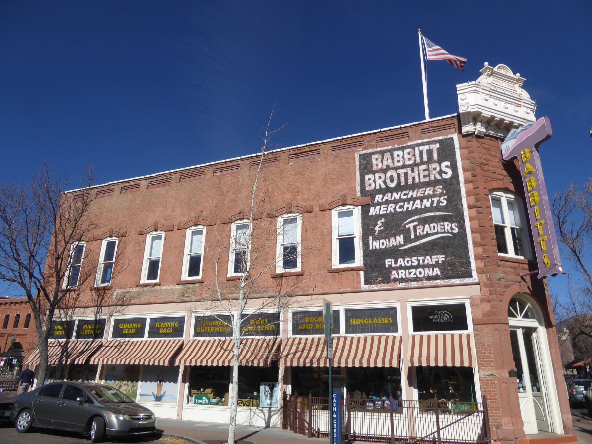
Downtown Flagstaff is compact and provided us with a delightful self-guided walking tour.


Orpheum Theater, 1917


Further west, a pre-1941 gravel detour took us to Parks.


The Parks in the Pines General Store and Post Office is still lively and operating. The original (1926-31) alignment of Route 66 was one block south, on the other side of the building. According to Jessica Dunham, the store kept up with the realignment by moving the front entrance to what had been the back door.


Williams, Arizona was the last town bypassed by Route 66 on October 13, 1984. There’s still a mural in the town commemorating this dark day. The citizens fought hard to preserve downtown Williams’s heritage as a Route 66 stop.


We were starving, so we stopped, as you do, in an 1897 bordello. The Red Garter Inn isn’t so much a saloon today as a nice diner.


The scenic (and expensive!) thing to do from Williams is to take a special train to the Grand Canyon. We’ve been to the Grand Canyon multiple times and were not doing this, but as we walked towards the railroad, I heard a woman say to T., “You’re in shorts and a T-shirt and I’m freezing in a jacket!”


She sure sounded familiar to me, and I wasn’t surprised when she said, “We’re from Tennessee.” I asked her where and she said near Knoxville. When I told her where I grew up, she said “Oh—we’re from Kingsport! I just didn’t know if you’d know where that was.” 


This was what I always thought when I used to tell people where I was from too. The couple was in Williams for a five-day trip, and if they were taking the Grand Canyon Railway, it must have been a memorable one.


From there we had to get back on the interstate for what T. termed “a rapid descent, not as rapid as the meteor!” 

The town of Ash Fork, the flagstone capital of America, was cut off by I-40. One man trying to change that is an Airbnb owner who stopped to talk to us while we were taking pictures of his place.


He told us that this old gas station is now his Airbnb, and they’re trying to restore more properties along the main drag of Ash Fork, so that it’s a worthy Route 66 stop like Williams.


Route 66 still exists as a historic and beloved route because of people like this man. Perhaps no one, though, deserves more credit than the founders of the Historic Route 66 Association of Arizona, which led to the foundation of other state organizations and made much of our trip possible.

Cutout of Angel Delgadillo with his barber chair!


Angel Delgadillo and his family, in the next town of Seligman, didn’t want their town to die. Thanks to their hard work and inspiration for others, there are now 159 miles of non-interstate Route 66 that you can drive through northern Arizona, beautiful and in good shape. There are series of replica Burma-Shave signs along the Crookton Road all the way to Seligman.


We didn’t actually meet Angel Delgadillo, but we did visit his barbershop, now a visitor center. 


Still following recommendations from Lile in Amarillo, we had dinner at the Roadkill Café (we had salad, so as to avoid roadkill, and leave room for pie!) There was a discount because we were staying next door at the Historic Route 66 Motel.


Seligman’s main street has lots of good businesses and some old neon too. The Stagecoach motel is run by Norwegians and has a big Norwegian flag out front. There’s another place run by Germans and advertising good hamburgers (naturally). Seligman is a favorite place of Route 66 travelers from all over the world.

Not quite Douglas Fairbanks


I got to talking to our next door neighbor at the motel, which is a Route 66 thing to do. I couldn’t guess her age, but I wouldn’t have thought, had she not told us, that she’d restored her own vintage Porsche and was now driving it all over the country by herself. 


And I don’t have a picture, but the starry sky at night over Seligman was better than I saw anywhere else on the trip—even the national parks.