

We were on Foothill Boulevard, Route 66 west of San Bernardino. Decades ago this was lined with fruit trees. Now a lot of it is modern sprawl, though there are still things to look out for.
 |
| Art Deco Standard Oil station, Rancho Cucamonga |

Rancho Cucamonga is, first of all, a great name for a town. Picture it as it was in Route 66’s heyday: orange groves, vineyards, wineries dating back as far as the 1830s! Now there are a lot of gas stations, none prettier than the 1915 Richfield station, preserved as a museum by enthusiastic volunteers.

 |
| Photo by Route 66 IECA (Inland Empire, California) |
The friendly volunteer here took our picture for the heritage association’s Facebook page. She showed us how every detail of the station has been restored—even the bell that rings when a customer drives (or in our case walks) up! “Are you going to the end of Route 66 today?” she asked. “It’s 90 degrees here but it’ll be nice in Santa Monica. Everybody will be going there today.”
Somewhere along Foothill Blvd., T. spotted a sign for the “first adobe house 1843.” I didn’t photograph anything quite that old, although the Sycamore Inn began as a stagecoach stop only five years later.

 |
| Magic Lamp Inn (1957) |
If you take the time to drive this way, the sights come thick and fast. Upland has one of twelve Madonna of the Trail statues, this one identical to the one we saw on old Route 66 in Albuquerque. Jerry McClanahan writes amusingly of “those sturdy women who had to listen to months of ‘How much longer?’ and ‘When will we be there?’ from the backseat of the covered wagon.”

There’s a market along the tree-lined boulevard through Claremont that’s been run for over a hundred years by the same family. La Verne has a classic building built in the mission style in 1928 (the restaurant and sign date back to 1966).
 |
| La Verne |
 |
| Pinnacle Peak Steakhouse, San Dimas |
I was determined to stop in Azusa. This town, “A to Z in the U.S.A.,” was where my great-grandmother (Gi Gi) spent the last years of her life. I remember addressing many notes to her address in Azusa, thanking her for the $2 bills she liked to send. I was too young then to know or appreciate Gi Gi’s colorful life, including a stint running a motel in Las Vegas, Nevada in the ’60s! Azusa has a tile and stucco City Hall (1932) as well as the preserved marquee of what was the Foothill Drive-in Theatre.


Mayan Revival is another style of architecture that has almost disappeared from the country. Fortunately, Monrovia’s Aztec Hotel (1925) is still there.

We were headed for Pasadena and, since Route 66 passes right through Old Town, there was no excuse not to see my cousins Adam and Alma and their two daughters. We’d last seen these folks when we stayed with them in 2018—back when we were traveling around the world—and, what with COVID-19 canceling Thanksgiving and everything else last year, were overdue for a visit. Alma and Adam and the girls were eager not only to see us, but to find us the best lunch in town.


Much as there are three different eastern ends of Route 66 in Chicago, so there are three different westernmost points. The original Route finished in downtown Los Angeles, at 7thand Broadway Streets. We’d been to L.A. on that 2018 trip, so the only part of this (1926-36) alignment we took was south on Fair Oaks Avenue. There’s a 1915 corner drugstore there that’s still a working pharmacy, but alas, it was a Sunday and closed. So all I got a picture of was Pasadena’s giant “Fork in the Road.”

From Pasadena, Route 66 into L.A. is the Arroyo Seco Parkway. This was the first freeway built west of the Mississippi River (1940), and for a freeway it’s quite attractive: lots of sweeping curves and overhanging concrete bridges with fetching designs. Modern freeways are built for higher speed limits so the Arroyo Seco probably has a frustrating volume of traffic now, but on a Sunday afternoon it was a decent drive. I guess “everybody” had already gone to the beach.
By Sunset Boulevard, my camera battery had died (first time on the trip!) and it wasn’t the kind of road it was easy to stop on. You have to take my word for it that we made it to Beverly Hills and its Art Moderne police station (I did not see Eddie Murphy there). “We’re the Beverly Hillbillies,” T. joked.

There’s an understated left turn (no light; thankfully traffic was light for L.A.) and the next thing you know, you’re on the final stretch of Route 66. “Santa Monica Boulevard 🎵,” T. sang. I could see the Hollywood sign intermittently appear on the hillside, when buildings weren’t blocking it.
In Santa Monica, the post-1936 alignment turns left on Lincoln Boulevard and ends at the intersection with Olympic.

The reason for this ending was that Route 66 was an actively used U.S. highway, and the rule was that every highway had to connect with another (U.S. Highway 101A, in this case). You couldn’t just end a highway driving into the sea.
However, as Ian at 66 to Cali (the kiosk on Santa Monica Pier) later told us, most travelers coming down Route 66 through Santa Monica had never seen the Pacific Ocean before. So on getting their first glimpse of the ocean, they ignored the left turn and just kept on going down Santa Monica Blvd.
Well. The first time I saw the Pacific, when I was fourteen, I'd never seen any ocean before. Today as navigator, I’d timed us to be there for sunset, and we were.


So it is picturesque and appropriate that now-decommissioned Route 66 does, indeed, dead end on the coast, at Santa Monica Pier.

This is the sign that tourists (not all of whom, I suspect, have just driven thousands of miles on Route 66) take pictures with, but neither sign is original. In fact, according to Ian, historically there was no “finish” sign at the western end of the Route. The Route 66 kiosk has reproduced the one at Lincoln and Olympic, though, placing it on the more scenic pier; and he helpfully took our picture with it.

We had to celebrate, and luckily we had friends to do so with. Konn, whom I’ve known for thirty years, and Danny came to see us in London in 2019 (B.C.), and now met up with us in their city.

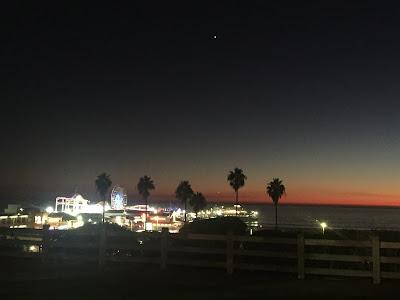
And we didn’t have to return the car till the next afternoon, so we had the morning to ride the Ferris wheel and enjoy Santa Monica Beach.

 |
| Georgian Hotel and Palisades Park |

Like the last time we were in California, I had conflicted feelings about the place. Sometimes the west coast feels as if it's just trying to do the opposite of whatever other states do, whether it makes sense or not. So many rules (smoking outside or vaccinations inside), yet such intolerance of homeless people, of whom California has an appalling number. In so many instances, public restrooms just forbidden. At least this one was open.

So. Three beginnings, three endings, 3,443 miles (including side trips). And countless American stories all along the way.

Reading through Jessica Dunham’s Route 66 Road Trip, researching this blog, I’m struck by historical details that I’d missed when we actually saw the places. The Armory in Chandler, Oklahoma was built to withstand tornado winds, and in 1958, Reverend Burton Z. “Lee Lee” Lewis was sworn into the Oklahoma National Guard there—the first African-American so to serve.

In Flagstaff, Arizona, the Museum Club was the site of Tanya Tucker’s first gig.

Meanwhile, Du Beau's Motel Inn, on pre-1934 Route 66 in downtown Flagstaff, was operated by the French-Canadian Albert Eugene Du Beau, who advertised in the Green Book this way: “Vacation & Recreation Without Humiliation.”

Also welcoming to black travelers were the ubiquitous Fred Harvey railroad hotels. From the Amtrak station (a.k.a. the museum) in Gallup, New Mexico to the Santa Fe Depot and Hotel in downtown Amarillo, Texas, more Harvey Houses remain than I had thought. And then there’s the fact that Mary Colter, of whom I’d previously never heard, designed a gazillion buildings in the Southwest (including almost every structure at the Grand Canyon).
If we made this trip again, one thing I know is that it would be very different. Not because I’d purposely change how we did it, but because Route 66 is always changing. Inevitably, some places we went would be closed; some of the places that were closed might well be open again. And even if we stuck to the same alignments of the Route and the same stops all the way across the country, the trip would never be the same, because we would meet different people.
Will Rogers, after whom the highway is also called, famously said that he never met a man he didn't like. Who can say that today? Yet I don't think Rogers was wrong about this: "You would be surprised what there is to see in this great country within 200 miles of where any of us live. I don't care what state or what town."
I’ve written before that I wish the U.S. national anthem were “America The Beautiful,” written by Katharine Lee Bates with music by Samuel A. Ward. This is my new favorite version, recorded and with additional words by the great Native-Canadian-American artist, Buffy Sainte-Marie (all lyrics below). After our trip on Route 66 I feel more positive about America, and I hope you do too.
There were Choctaws in Alabama
Chippewas in St. Paul
Mississippi mud runs like a river in me
America, ooh, she's like a mother to me
O beautiful for spacious skies
For amber waves of grain
For purple mountain majesty
Above the fruited plain
America, America
God shed His grace on thee
And crown thy good with brotherhood
From sea to shining sea
From sea to shining sea
There were cliff towns in Colorado
Pyramids in Illinois
Trade routes up and down the Mississippi River to see
America, ooh, she's like a mother to me
O beautiful for vision clear
That sees beyond the years
Thy night time sky
Our hopes that fly
Undimmed by human tears
America, America
God shed His grace on thee
'Til selfish gain no longer stain
The banner of the free
From sea to shining sea


